TheiaX GmbH
Booth number: 6113N-6
www.theiax.de
About us
TheiaX GmbH provides fast and efficient raw material discovery and characterization using non-invasive hyperspectral imaging technics. Combined with robust machine learning driven data processing routines, our products consist of digital twins of drill-cores and outcrops, which are derived through our three main services:
CORE - Mineral characterisation of drill-cores and hand specimens
PIT - Mineral mapping of open pits and outcrops
MAP - Regional mineral and prospectivity mapping


Address
Chemnitzer Str. 40
09599 Freiberg
Germany
E-mail: services@theiax.de
Phone: +49 373 13773890
Internet: www.theiax.de
Contact person:
Christian Christesen
Managing Director / Co-Founder
E-mail: c.christesen@theiax.de
Phone: +49 373 13773891
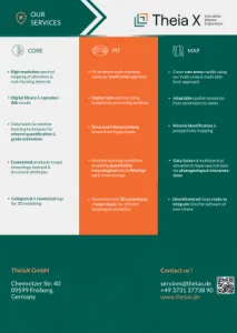
Products & Services
CORE - Mineral characterisation of drill-cores and hand specimens
PIT - Mineral mapping of open pits and outcrops
MAP - Regional mineral and prospectivity mapping
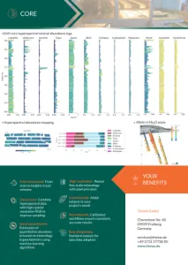
CORE - Mineral characterisation of drill-cores and hand specimens
Quick turnaround. From scan to insights in just minutes
High-resolution. Fine-scale mineralogy with pixel precision
Data fusion. Combine hyperspectral data with high-spatial resolution RGB to improve sampling
Quasi-quantitative. Estimation of quantitative abundances based on mineralogy & geochemistry using machine learning algorithms
Customizable. Adapt outputs to your project's needs
Reproducible. Calibrated workflows ensure consistent, accurate results
Easy integration. Standard outputs for easy data adoption

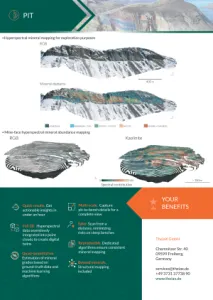
PIT - Mineral mapping of open pits and outcrops
Quick results. Get actionable insights in under an hour
Full 3D. Hyperspectral data seamslessly integrated into point clouds
Multi-scale. Capture pit-to-bench details for a complete view
Quasi-quantitative. Estimation of mineral grades based on ground-truth data and machine learning algorithms
Safer. Scan from a distance, minimizing risks on steep benches
Beyond minerals. Structural mapping included
Reproducible. Dedicated algorithms ensure consistent mineral mapping
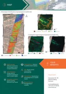
MAP - Regional mineral and prospectivity mapping
Wide coverage. Efficient characterisation of square meters to square kilometers
Multi-platform. Airborne & satellite-based mapping
Data integration. Merge spectral, elevation & geological data for deep insights
Adaptable resolution. Spatial sampling tailored to your needs
Beyond minerals. Photogeological mapping
Reproducible. Standardized processing ensures realiable results
Safe. Access remote areas without personnel risk